SERENGETI NATIONAL PARK
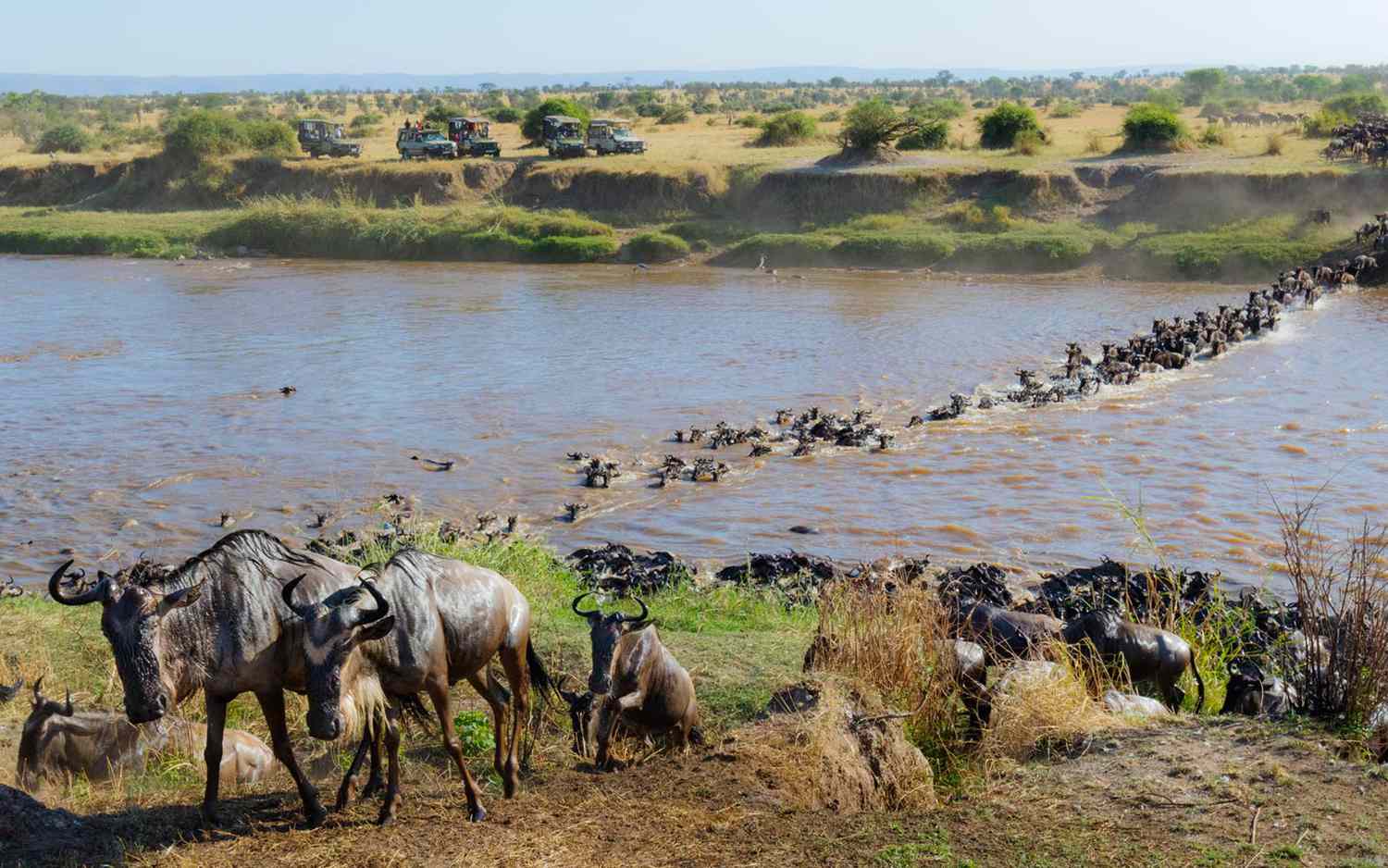
Let the great migration in this dynamic ecosystem move you. It’s the only place where you can witness millions of migrating wildebeest over the Acacia plains; it’s the cradle of human life, and probably the closest to an untouched African wilderness you will ever get: welcome to Serengeti National Park. Where time seems to stand still, despite the thousands of animals constantly on the move.
The greatest wildlife destination on earth
The magic of Serengeti National Park is not easy to describe in words. Not only seeing, but also hearing the buzz of millions of wildebeest so thick in the air that it vibrates through your entire body is something you will try to describe to friends and family, before realizing it’s impossible. Vistas of honey-lit plains at sunset so beautiful, it’s worth the trip just to witness this. The genuine smiles of the Maasai people, giving you an immediate warming glow inside. Or just the feeling of constantly being amongst thousands of animals – it doesn’t matter what season of the migration you visit the Serengeti National Park, its magical all year round
The never-ending circle of the Great Migration
Serengeti National Park was one of the first sites listed as a World Heritage Site when United Nations delegates met in Stockholm in 1981. Already by the late 1950s, this area had been recognized as a unique ecosystem, providing us with many insights into how the natural world functions and showing us how dynamic ecosystems really are.
Beyond the Great Migration
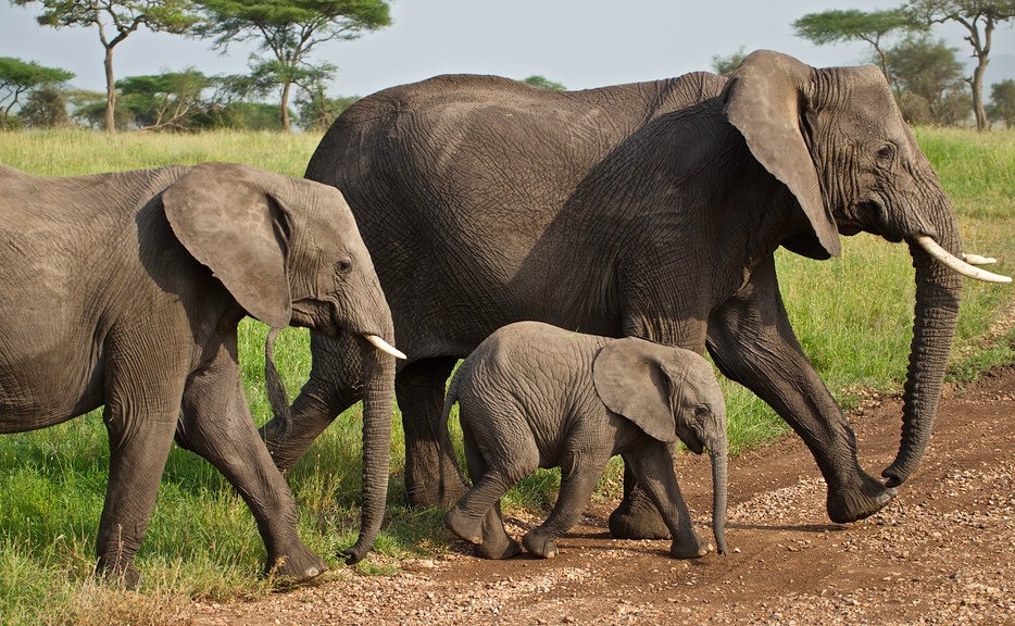
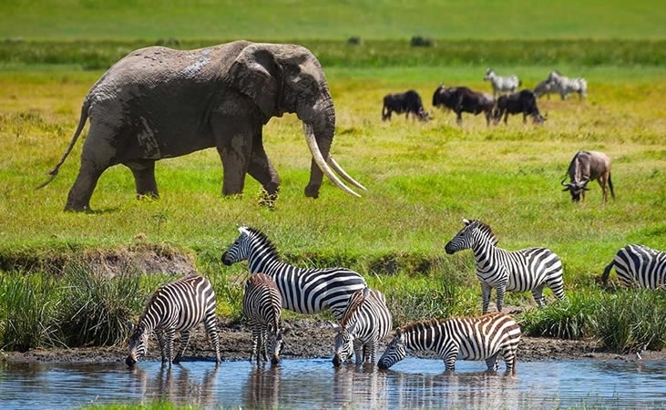
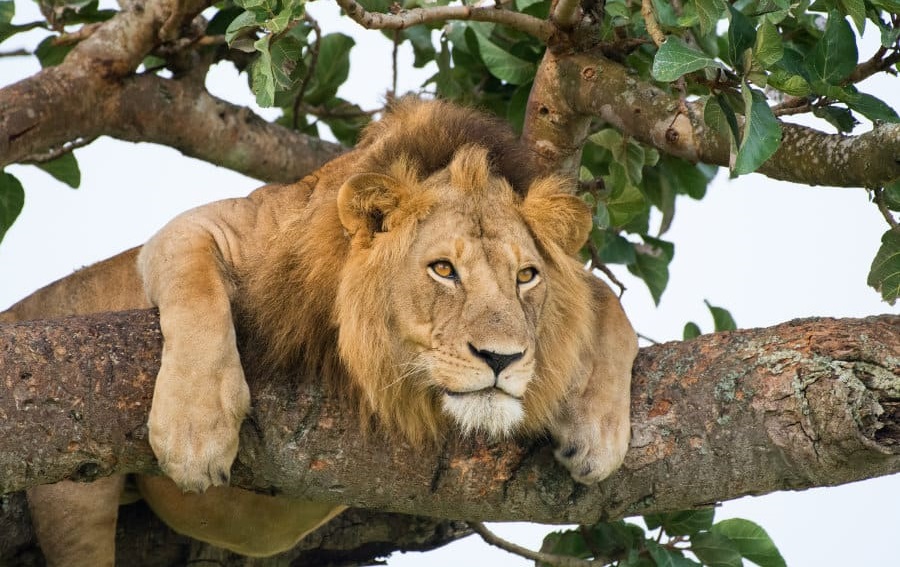
Even though, for many travelers, the migration is one of the main reasons to visit Serengeti National Park, it’s worth looking beyond this immense spectacle. First of all, nature can’t be directed. Having realistic expectations of your chances to witness a river crossing, or a large herd on the move, is crucial. A river crossing for example often only lasts thirty minutes so can be missed in the blink of an eye. But don’t let this discourage you: there are plenty of other reasons to visit the Serengeti. If it’s not for this vast stretch of land where you can drive forever and never get enough, it might be for the incredible skies of dazzling colors or the primal feeling of excitement when a deep dark-grey thunderstorm appears on the broad horizon. Or you might answer the lion’s call, and come to the Serengeti for one of the largest concentrations of predators in the world: the herds support about 7,500 hyenas, 3,000 lions and 250 cheetahs. And how about the silent grey giants? Elephants in the Serengeti amble over the plains into the woodlands, feasting on leaves and tree branches. Read more about wildlife in Serengeti wildlife.
Tribes in the cradle of human life
Even though animals still rule the plains of the Serengeti, this area has an incredibly long history of human occupation. Not only humans, but also human ancestors (Australopithecus forensic) lived in this area for almost 4 million years. Today, Serengeti National Park is still home to several indigenous tribes. One of the most famous tribes is the Maasai: this tribe is unique and popular due to their long-preserved culture. Despite education, civilization and western cultural influences, the Maasai people have clung to their traditional way of life, making them a symbol of Tanzanian and Kenyan culture. Read more about the Maasai people.
Vibrancy, variety and vastness
You will soon realize that amazement doesn’t have boundaries in this world-renowned National Park of Tanzania. Serengeti is a transition area, with distinct changeovers going from rich flat soils, to poor hilly soils in the north, attracting a wide variety of vegetation and animals. Whether you are looking for big cats, birds or even smaller creatures: Serengeti National Park delivers. Even to understand and experience just a small part of this ecosystem, will change your vision on our world and the environment. After being overwhelmed by the vibrancy, variety and vastness of this land, this place of transition will leave you changed forever
History of Serengeti National Park
In the late 1800s and early 1900s, explorers and missionaries described the Serengeti plains and the massive numbers of animals found there. Only minor details are all that were reported before explorations in the late 1920s and early 1930s supply the first references to the great wildebeest migrations, and the first photographs of the region. An area of 2,286 square kilometers was established in 1930 as a game reserve in what is now southern and eastern Serengeti. They allowed sport hunting activities until 1937, after which it stopped all hunting activities. In 1940 Protected Area Status was conferred to the area and the National Park itself was established in 1951, then covering southern Serengeti and the Ngorongoro highlands. They based the park headquarters on the rim of Ngorongoro crate
So, the original Serengeti National Park, as it was gazette in 1951, also included what now is the Ngorongoro Conservation Area (NCA). In 1959, the Ngorongoro Conservation Area was split off from the Serengeti National Park and they extended the boundaries of the park to the Kenya border. The key reason for splitting off the Ngorongoro area was that local Maasai residents realized that they were threatened with eviction and consequently not allow grazing their cattle within the national park boundaries. To counter this from happening, protests were staged. A compromise was reached wherein the Ngorongoro Crater Area was split off from the national park: the Maasai may live and graze their cattle in the Ngorongoro Crater area but not within Serengeti National Park boundaries.
In 1961 the Maasai Mara National Reserve in Kenya was established and in 1965 the Lamai Wedge between the Mara River and Kenya border was added to Serengeti National Park, thus creating a permanent corridor allowing the wildebeests to migrate from the Serengeti plains in the south to the Loita Plains in the north. The Maswa Game Reserve was established in 1962 and a small area north of The Grumeti River in the western corridor was added in 1967. The Serengeti National Park was among the first places to be proposed as a World Heritage Site by UNESCO at 1972 Stockholm conference. It was formally established in 1981.
Geology of Serengeti National Park
The Serengeti ecosystem is part of East Africa’s high interior plateau. It slopes from its highest parts in the crater highlands (at an altitude 3,636 meters) towards Speke Gulf on Lake Victoria (920 meters above sea level). The highlands result from volcanic activity related to plate tectonics of the Rift valley. The area still has one active volcano: Ol Doinyo Lengai, which means ‘mountain of God’ in the local Maa language. Learn all about Serengeti's geology on this page
River in the Serengeti
The Serengeti plains are at an elevation between 1,600 and 1,800 meter above sea level. Several river catchments drain the area. The Mara River in the north flows from the Mau forests in the Kenyan highlands, southwards through the Maasai Mara National Reserve, then west through northern Serengeti, out through the great Masarua marshes, and ultimately into Lake Victoria at Musoma. This is the only permanently flowing river in the Serengeti ecosystem. It supports dense riverine forests on its banks in the Mara, and along its major tributaries in Serengeti National Park. South of the Mara are the parallel catchments of the Grumeti and Mbalaget Rivers that form the Western Corridor of Serengeti National Park. Further south there are the much smaller Duma, Simiyu and Semu rivers flowing through Maswa Game Reserve. The area is undulating and dissected by many small seasonal streams that drain into the main rivers.
Hills & mountains
There are bands of hills that rise steeply from this relatively flat landscape. One band forms the north-eastern boundary of Serengeti National Park in the woodlands, running north from Grumechen to Kuko, and then joining the Loita Hills in Kenya. The Gol Mountains rise from the Serengeti plains east of the park. Another band stretches from Seronera west along the corridor to form the Central Ranges, and a third group of hills lies in the south forming the Nyaraboro-Itonjo plateau.
Soils & volcanic history
West of the line Mugumu - Seronera the underlying rocks are ancient (600 million to 2.5 billion years) and comprise Precambrian volcanic rocks, banded ironstones and mineral-poor granites. Late Precambrian sedimentary rocks cover this shield and form the central and southern hills. East of Seronera, granite and quartzite form the eastern hills and kopjes. The western corridor is of more recent geological history; it is a complex of unconsolidated sediments and alluvial formations, which form the base for more nutrient-rich soils. The Crater Highlands are volcanoes of the Pleistocene age and comprise basic igneous rocks and basalt. One volcano, Ol Doinyo Lengai, is still active with the last eruption dating back to 2013.
Africa is an old continent. Evidence suggests it is as old as 4 billion years, older than Europe or North America. We can see this old age from the air (so have a good peek when arriving into Kilimanjaro Airport). Millions of years of weathering have flattened mountains and turned much of Africa into a series of endless, rolling plains and hills. One exception is the geologically active East African Rift system.
The East African Rift is the area where two tectonic plates are moving away from one another. The resulting cracks have produced both the immense Rift Valley and the volcanoes on either side of it. Kilimanjaro, Mount Kenya, and Mount Meru are a few of the best-known examples of the Rift's volcanoes. Although Ngorongoro Crater looks like an extinct volcano, geological surveys suggest it never exploded, however most of its immediate neighbors did. Ngorongoro Crater is a caldera, which means the mountain is collapsing on itself as the tectonic plates separate.
The volcanoes of the East African Rift are relatively young. As these volcanoes erupted, they covered the eastern parts of Serengeti with ash and larger particles. This volcanic ash on the plains creates a very specific type of soil rich in minerals. Eastern plains soils contain different salts, such as sodium, potassium, , and calcium. The soil here is shallow because of the formation of a calcareous hardpan, also known as caliche. During the regional rains, salts are washed down into the soil. As water is removed by plant uptake, the soluble substances precipitate and the caliche layer develops and cements through lime. Soils in the Serengeti become deeper (where the hardpan disappears) towards the northwest plains and into the woodlands, because of more rainfall and less calcium. At levels of precipitation too high for hardpan formation, a characteristic soil catena is found. This is the gradient of soil types from ridge top to drainage pump, characterized by a sandy, shallow, well-drained soil at the top transforming to poorly drained and deep silty soil at the bottom. This catena form because of the long-term downwash of the finer soil particles downslope with surface run-off.
Kopjes
Below the layers of volcanic rock and ash, that form the soil of Serengeti National Park, is a thick layer of extremely old rock. A giant bubble of liquid granite forced its way up from the molten rock below the Earth’s crust and into the Tanganyika Shield in the late Precambrian period. Today, as the softer rocks wear off, it exposes the jagged top of this granite layer, forming kopjes (pronounced ‘kop-eez'). The granite is cracked by the repeated heating and cooling under the African sun and weathered into interesting shapes by the wind. Most kopjes are round or have round boulders on them.
Kopjes are a distinctive feature of the Serengeti landscape and are often referred to as ‘islands in a sea of grasses. They provide protection from bushfires, hold more water in the direct vicinity, offer a hiding place for animals, and a vantage point for predators. Hundreds of plant species grow on kopjes, but not in the surrounding grasslands. Many animal species live on kopjes only because of the presence of these plants, and for reasons of protection. These animals include insects, lizards, and snakes, but also mammals such as shrews and mice, up to large specialist mammals, such as lions. Kopjes are one of the best places to see lions, and occasionally cheetah or leopard
Beyond the Great Migration
Even though, for many travelers, the migration is one of the main reasons to visit Serengeti National Park, it’s worth looking beyond this immense spectacle. First of all, nature can’t be directed. Having realistic expectations of your chances to witness a river crossing, or a large herd on the move, is crucial. A river crossing for example often only lasts thirty minutes so can be missed in the blink of an eye. But don’t let this discourage you: there are plenty of other reasons to visit the Serengeti. If it’s not for this vast stretch of land where you can drive forever and never get enough, it might be for the incredible skies of dazzling colors or the primal feeling of excitement when a deep dark-grey thunderstorm appears on the broad horizon. Or you might answer the lion’s call, and come to the Serengeti for one of the largest concentrations of predators in the world: the herds support about 7,500 hyenas, 3,000 lions and 250 cheetahs. And how about the silent grey giants? Elephants in the Serengeti amble over the plains into the woodlands, feasting on leaves and tree branches. Read more about wildlife in Serengeti wildlife.
Tribes in the cradle of human life
Even though animals still rule the plains of the Serengeti, this area has an incredibly long history of human occupation. Not only humans, but also human ancestors (Australopithecus forensic) lived in this area for almost 4 million years. Today, Serengeti National Park is still home to several indigenous tribes. One of the most famous tribes is the Maasai: this tribe is unique and popular due to their long-preserved culture. Despite education, civilization and western cultural influences, the Maasai people have clung to their traditional way of life, making them a symbol of Tanzanian and Kenyan culture. Read more about the Maasai people.
Vibrancy, variety and vastness
You will soon realize that amazement doesn’t have boundaries in this world-renowned National Park of Tanzania. Serengeti is a transition area, with distinct changeovers going from rich flat soils, to poor hilly soils in the north, attracting a wide variety of vegetation and animals. Whether you are looking for big cats, birds or even smaller creatures: Serengeti National Park delivers. Even to understand and experience just a small part of this ecosystem, will change your vision on our world and the environment. After being overwhelmed by the vibrancy, variety and vastness of this land, this place of transition will leave you changed forever
History of Serengeti National Park
In the late 1800s and early 1900s, explorers and missionaries described the Serengeti plains and the massive numbers of animals found there. Only minor details are all that were reported before explorations in the late 1920s and early 1930s supply the first references to the great wildebeest migrations, and the first photographs of the region. An area of 2,286 square kilometers was established in 1930 as a game reserve in what is now southern and eastern Serengeti. They allowed sport hunting activities until 1937, after which it stopped all hunting activities. In 1940 Protected Area Status was conferred to the area and the National Park itself was established in 1951, then covering southern Serengeti and the Ngorongoro highlands. They based the park headquarters on the rim of Ngorongoro crate
So, the original Serengeti National Park, as it was gazette in 1951, also included what now is the Ngorongoro Conservation Area (NCA). In 1959, the Ngorongoro Conservation Area was split off from the Serengeti National Park and they extended the boundaries of the park to the Kenya border. The key reason for splitting off the Ngorongoro area was that local Maasai residents realized that they were threatened with eviction and consequently not allow grazing their cattle within the national park boundaries. To counter this from happening, protests were staged. A compromise was reached wherein the Ngorongoro Crater Area was split off from the national park: the Maasai may live and graze their cattle in the Ngorongoro Crater area but not within Serengeti National Park boundaries.
In 1961 the Maasai Mara National Reserve in Kenya was established and in 1965 the Lamai Wedge between the Mara River and Kenya border was added to Serengeti National Park, thus creating a permanent corridor allowing the wildebeests to migrate from the Serengeti plains in the south to the Loita Plains in the north. The Maswa Game Reserve was established in 1962 and a small area north of The Grumeti River in the western corridor was added in 1967. The Serengeti National Park was among the first places to be proposed as a World Heritage Site by UNESCO at 1972 Stockholm conference. It was formally established in 1981.
Geology of Serengeti National Park
The Serengeti ecosystem is part of East Africa’s high interior plateau. It slopes from its highest parts in the crater highlands (at an altitude 3,636 meters) towards Speke Gulf on Lake Victoria (920 meters above sea level). The highlands result from volcanic activity related to plate tectonics of the Rift valley. The area still has one active volcano: Ol Doinyo Lengai, which means ‘mountain of God’ in the local Maa language. Learn all about Serengeti's geology on this page
River in the Serengeti
The Serengeti plains are at an elevation between 1,600 and 1,800 meter above sea level. Several river catchments drain the area. The Mara River in the north flows from the Mau forests in the Kenyan highlands, southwards through the Maasai Mara National Reserve, then west through northern Serengeti, out through the great Masarua marshes, and ultimately into Lake Victoria at Musoma. This is the only permanently flowing river in the Serengeti ecosystem. It supports dense riverine forests on its banks in the Mara, and along its major tributaries in Serengeti National Park. South of the Mara are the parallel catchments of the Grumeti and Mbalaget Rivers that form the Western Corridor of Serengeti National Park. Further south there are the much smaller Duma, Simiyu and Semu rivers flowing through Maswa Game Reserve. The area is undulating and dissected by many small seasonal streams that drain into the main rivers.
Hills & mountains
There are bands of hills that rise steeply from this relatively flat landscape. One band forms the north-eastern boundary of Serengeti National Park in the woodlands, running north from Grumechen to Kuko, and then joining the Loita Hills in Kenya. The Gol Mountains rise from the Serengeti plains east of the park. Another band stretches from Seronera west along the corridor to form the Central Ranges, and a third group of hills lies in the south forming the Nyaraboro-Itonjo plateau.
Soils & volcanic history
West of the line Mugumu - Seronera the underlying rocks are ancient (600 million to 2.5 billion years) and comprise Precambrian volcanic rocks, banded ironstones and mineral-poor granites. Late Precambrian sedimentary rocks cover this shield and form the central and southern hills. East of Seronera, granite and quartzite form the eastern hills and kopjes. The western corridor is of more recent geological history; it is a complex of unconsolidated sediments and alluvial formations, which form the base for more nutrient-rich soils. The Crater Highlands are volcanoes of the Pleistocene age and comprise basic igneous rocks and basalt. One volcano, Ol Doinyo Lengai, is still active with the last eruption dating back to 2013.
Africa is an old continent. Evidence suggests it is as old as 4 billion years, older than Europe or North America. We can see this old age from the air (so have a good peek when arriving into Kilimanjaro Airport). Millions of years of weathering have flattened mountains and turned much of Africa into a series of endless, rolling plains and hills. One exception is the geologically active East African Rift system.
The East African Rift is the area where two tectonic plates are moving away from one another. The resulting cracks have produced both the immense Rift Valley and the volcanoes on either side of it. Kilimanjaro, Mount Kenya, and Mount Meru are a few of the best-known examples of the Rift's volcanoes. Although Ngorongoro Crater looks like an extinct volcano, geological surveys suggest it never exploded, however most of its immediate neighbors did. Ngorongoro Crater is a caldera, which means the mountain is collapsing on itself as the tectonic plates separate.
The volcanoes of the East African Rift are relatively young. As these volcanoes erupted, they covered the eastern parts of Serengeti with ash and larger particles. This volcanic ash on the plains creates a very specific type of soil rich in minerals. Eastern plains soils contain different salts, such as sodium, potassium, , and calcium. The soil here is shallow because of the formation of a calcareous hardpan, also known as caliche. During the regional rains, salts are washed down into the soil. As water is removed by plant uptake, the soluble substances precipitate and the caliche layer develops and cements through lime. Soils in the Serengeti become deeper (where the hardpan disappears) towards the northwest plains and into the woodlands, because of more rainfall and less calcium. At levels of precipitation too high for hardpan formation, a characteristic soil catena is found. This is the gradient of soil types from ridge top to drainage pump, characterized by a sandy, shallow, well-drained soil at the top transforming to poorly drained and deep silty soil at the bottom. This catena form because of the long-term downwash of the finer soil particles downslope with surface run-off.
Kopjes
Below the layers of volcanic rock and ash, that form the soil of Serengeti National Park, is a thick layer of extremely old rock. A giant bubble of liquid granite forced its way up from the molten rock below the Earth’s crust and into the Tanganyika Shield in the late Precambrian period. Today, as the softer rocks wear off, it exposes the jagged top of this granite layer, forming kopjes (pronounced ‘kop-eez'). The granite is cracked by the repeated heating and cooling under the African sun and weathered into interesting shapes by the wind. Most kopjes are round or have round boulders on them.
Kopjes are a distinctive feature of the Serengeti landscape and are often referred to as ‘islands in a sea of grasses. They provide protection from bushfires, hold more water in the direct vicinity, offer a hiding place for animals, and a vantage point for predators. Hundreds of plant species grow on kopjes, but not in the surrounding grasslands. Many animal species live on kopjes only because of the presence of these plants, and for reasons of protection. These animals include insects, lizards, and snakes, but also mammals such as shrews and mice, up to large specialist mammals, such as lions. Kopjes are one of the best places to see lions, and occasionally cheetah or leopard
So, the original Serengeti National Park, as it was gazette in 1951, also included what now is the Ngorongoro Conservation Area (NCA). In 1959, the Ngorongoro Conservation Area was split off from the Serengeti National Park and they extended the boundaries of the park to the Kenya border. The key reason for splitting off the Ngorongoro area was that local Maasai residents realized that they were threatened with eviction and consequently not allow grazing their cattle within the national park boundaries. To counter this from happening, protests were staged. A compromise was reached wherein the Ngorongoro Crater Area was split off from the national park: the Maasai may live and graze their cattle in the Ngorongoro Crater area but not within Serengeti National Park boundaries.
In 1961 the Maasai Mara National Reserve in Kenya was established and in 1965 the Lamai Wedge between the Mara River and Kenya border was added to Serengeti National Park, thus creating a permanent corridor allowing the wildebeests to migrate from the Serengeti plains in the south to the Loita Plains in the north. The Maswa Game Reserve was established in 1962 and a small area north of The Grumeti River in the western corridor was added in 1967. The Serengeti National Park was among the first places to be proposed as a World Heritage Site by UNESCO at 1972 Stockholm conference. It was formally established in 1981.
The East African Rift is the area where two tectonic plates are moving away from one another. The resulting cracks have produced both the immense Rift Valley and the volcanoes on either side of it. Kilimanjaro, Mount Kenya, and Mount Meru are a few of the best-known examples of the Rift's volcanoes. Although Ngorongoro Crater looks like an extinct volcano, geological surveys suggest it never exploded, however most of its immediate neighbors did. Ngorongoro Crater is a caldera, which means the mountain is collapsing on itself as the tectonic plates separate.
The volcanoes of the East African Rift are relatively young. As these volcanoes erupted, they covered the eastern parts of Serengeti with ash and larger particles. This volcanic ash on the plains creates a very specific type of soil rich in minerals. Eastern plains soils contain different salts, such as sodium, potassium, , and calcium. The soil here is shallow because of the formation of a calcareous hardpan, also known as caliche. During the regional rains, salts are washed down into the soil. As water is removed by plant uptake, the soluble substances precipitate and the caliche layer develops and cements through lime. Soils in the Serengeti become deeper (where the hardpan disappears) towards the northwest plains and into the woodlands, because of more rainfall and less calcium. At levels of precipitation too high for hardpan formation, a characteristic soil catena is found. This is the gradient of soil types from ridge top to drainage pump, characterized by a sandy, shallow, well-drained soil at the top transforming to poorly drained and deep silty soil at the bottom. This catena form because of the long-term downwash of the finer soil particles downslope with surface run-off.
NORTHERN TANZANIA WILDLIFE ATTRACTIONS